

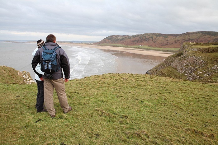
Rhossili to Mewslade Bay Walking Route
Take one of the 'Top 10 Coastal Walking Routes' recommended by the Ramblers' Association. The Ramblers' Association named this beautiful, round route on the western border of the Gower Peninsula as one of their 'Top 10 Coastal Walking Routes.'
Walk Summary :-
Walk Grade: Easy
Route Type: Circular
Distance Covered: About 3 Miles /4.8 Km
Average Time: 2-3 Hours
Suitable for: All
Terrain: The walk covers clifftops, grassy paths, field paths and lanes
Start: Rhossili Car Park (fee applicable for private parking)
Finish: Rhossili Car Park
Useful Information :-
Public Transport: Yes
Car Parking: At Rhossili (fee applicable for private parking)
Refreshments: At the Worm's Head Hotel just across from the car park, and the shop at the top of the car park
Public Toilets: At the bottom area of the car park
Be Prepared: Waterproof clothing and strong boots or shoes
Safety Information :-
Read the notices posted in the National Trust Visitor Centre and Shop window and the historic coastguard lookout hut if you intend to venture out onto the Worm itself. These provide information on tide timings and spots to avoid during the bird breeding season. Before you go, please notify the coastguard.
Details of Walk :-
- Pass the coastguard cottages and the National Trust Visitor Centre and Store on your left as you exit the car lot at the Worm's Head ends. Pass through a wooden gate and onto a wide path that leads to the Worm, keeping a stone wall on your left. Continue on this path for about 0.5 miles (0.8 Km), crossing the somewhat lumpy ground on your right, which indicates the location of an old Iron Age fort. Continue ahead through a broad grassy turf as far as the old coastguard lookout hut, where the track swings to the left alongside the wall (now operated by the Countryside Council for Wales as a tourist centre).
- Turn left here and follow the cliff path for about 0.75 miles (1.2 Km), skirting around Fall Bay before continuing to Mewslade Bay, just before the prominent Thurba headland. Keep to the higher path alongside the field wall, as the lower way heading down to Fall Bay is no longer legally a footpath after being closed down a few years ago.
- Do not turn left over the iron ladder stile at the eastern end of Fall Bay. Instead, stay to the left of the wall and follow the cliff path as it swings to the right. Continue around the headland on the way to Mewslade Bay. Take the trail to the right, where it splits to get the best views of the cliff-top beauty in this area. It finally connects with the path that runs alongside the wall further down the road.
- A huge fig tree approximately halfway down the hillside on the right marks the start of the trail. Stay on it as the route swings to the left above and across the Mew Slade. Turn right down a green strip to the bottom of the valley about 50 yards (46 metres) before it rejoins the main route at the wall. Turn left up the valley when you join the way at the bottom. Enter a stony track through a gate. Continue to Pitton Farm, passing through a second gate.
- Turn left, passing a few cottages on your left, to reach Rhossili's main road. Cross the street to the lane next to the post office, ahead and slightly to the right. Continue straight up the lane until it splits into two tracks. Ascend slowly on the left route (marked by a waypoint arrow on the telegraph pole). You will pass a cottage on your left and a house straight. Cross over a stile on the left, indicated by a waymark arrow and a 'Glamorgan Naturalists Trust – Nature Reserve' sign, around 50 yards (46 metres) past the house (a body currently more precisely known as the Glamorgan Wildlife Trust). The trail is a little overgrown here, but it's never difficult to find. Pass an ancient thatched farmhouse on your left and cross a stile to exit the reserve. To connect an old overgrown brick driveway, turn half right. Continue to the right of a gate to a stile. Cross the stile onto a lane and head straight for the track ahead of you.
- Turn left downwards along the lane to connect the main road via Rhossili. The path will lead you to a Welsh Water reservoir. Turn left as soon as you pass the reservoir and look for the white house ahead and slightly to the left. Pick up a stone wall (not literally) just past the house and follow it, maintaining it on your left and continuing on the common. Stay on the common and to its right, rather than crossing a signposted stile over the wall. Continue for about 20 yards (18 metres) to reach the vast and grassy route coming off Rhossili Down, where it turns abruptly left above Rhossili. Return to the parking park by turning right, either via St Mary's Church or down the road.
Highlights :-
- You'll see some bumpy ground to your right around halfway along the cliff path between Rhossili and the old rescue team lookout point. This is all that's left of Historic Castle, an old iron-age fort. It has been ravaged by time and nearby quarrymen's activity and is now only visible as a sequence of humps and tracks.
- ‘The Viel' (or 'The Vile'), which is old Gower dialect for a field, is on the other side of the track and over the stone wall. The Viel is one of the rare remnants of the mediaeval open field strip system that has survived. The concept was that local farmers would be given strips of land from various places to ensure that everyone got a fair portion of the "good" and "not so good" quality land.
- The rather oddly and quaintly named Kitchen Corner is just along from here and below the old coastguard lookout. Mr Coonan, a Swansea fisherman, built the wooden shelter at the bottom of the cliffs to allow him to fish for bass off the cliff edge as well as launch his boat. If you want to have a closer look, there's a path that leads down to it.
- The 'Worm's Head' is a spectacular promontory with three unique sections: the Inner, Middle, and Outer Heads, which have a serpent-like appearance. It is held by the National Trust and is a haven for sea birds such as kittiwakes, razorbills, guillemots, and several varieties of gulls. It is only accessible during low tide. If you plan to cross the Worm, make a mental note of the tide times displayed at the National Trust shop in Rhossili and inform the coastguard before you go.
- Mewslade Bay, like Fall Bay directly before it, is one of those beaches that entirely disappears at high tide. It's a popular and safe swimming spot. Rock climbers come to this area because of the stunning limestone cliffs. The name's origin is unknown; however, it is widely assumed to be derived from the old term 'Mew,' which means "seagull." They are also home to seabird colonies, particularly kittiwakes, who have successfully bred here since the 1940s. The term "slade" appears to refer to a dry grassy valley that runs down to the sea and is usually shrouded with furze or gorse.
- Petty Officer Edgar Evans of Scott's ill-fated Antarctic expedition was born in Middleton. Inside Rhossili church, there is a moving memorial to him. Middleton was also home to some of Gower's most notorious smugglers, even though a tour around the town now would lead you to believe the contrary. The Ship Inn was one of three inns in the area at the turn of the century (now Ship Cottage). It's also said that they all had multiple cellars!